Markus Stowasser: There are a couple of reasons for this massive outbreak of tornadoes.
An age of severe storms?
These were the deadliest tornadoes in the US since 1925 and the worst natural disaster since Hurricane Katrina. What happened?
Moist and warm air from the Gulf of Mexico has been constantly drifting north. At the same time, cold fronts have been rushing in from the northwest. The two airflows clashed over the Midwest and South of the US and spawned storms and tornadoes.
An important additional factor was a large and very strong jet stream disturbance with strong winds in the higher atmosphere. The strength of this disturbance provided the energy to support high-intensity tornadoes.
And the large size of the disturbance allowed strong storms to develop over a larger area than normal.

Markus Stowasser: "The reported losses in the US indicate a trend towards an increase of severe convective weather phenomena including tornadoes."
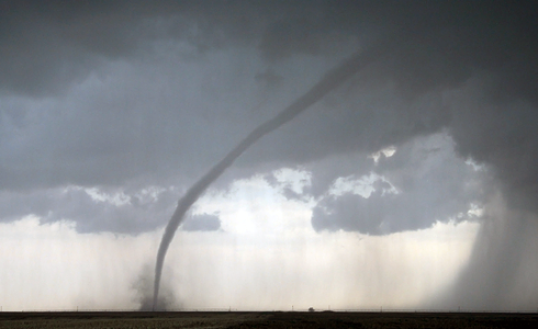
How do tornadoes develop?
Stowasser: The most important ingredient for a tornado is warm and moist air, coming from the Gulf of Mexico for example. It carries a lot of energy which will be set free as soon as it is forced to rise. At the same time, cold air flows into higher altitudes, which makes the atmosphere unstable.
Thunderstorms form in the uprising warm air until they end up in a super cell. Super cells are enormous cloud systems which can be up to 10 kilometers wide and are the largest type of thunderstorms on earth. Super cell thunderstorms are characterized by a persistent rotating updraft and form in environments of strong vertical wind shear—the change in wind speed or direction with height.
These conditions are often seen in areas of jet streams—regions of strong wind speeds in higher altitudes. Super cells are responsible for most tornadoes when winds inside the cells send funnel clouds spinning towards the ground.
The last 30 years of raw data clearly show an increase in the number of tornadoes
People living in 'Tornado Alley' are used to these storms. But this time more than 340 people died. What made this event so exceptional?
Stowasser: This was indeed a very exceptionally violent weather event with up to 160 tornadoes within 24 hours. The last time we saw such a high number of tornado clusters in a corresponding period of time was in 1974. Back then we counted 148 tornadoes.
Since the beginning of this year, however, we have noticed 745 tornadoes, an outstanding figure that has never been recorded before. Normally in the US we see around 1200 tornadoes on average throughout the year.
Certainly the peak season for these kinds of storms has started way earlier than usual. But these storms didn't really differ from other similar events. These storms are where they are expected to be at this time of year.
Unfortunately, the conditions were just perfect for this tornado event and all risk factors aligned themselves optimally which makes such an outbreak a relatively rare event.
What makes the Midwest and South of the U.S. so vulnerable to tornadoes?
Stowasser: It's a combination of topographical elements.
Unlike in Central Europe there is no mountain range like the Alps blocking the exchange of air streams from the north to the south or vice versa. Dry, cold air can reach very far south and moist, warm air can travel far north. It is these conditions that make the tornado alley quite unique.
How predictable are tornadoes?
Stowasser: Tornadoes are very hard to predict. There are some indications in the weather models which help to issue warnings but tornado formation isn't fully understood.
We can say that there is a higher risk today than on another given day but when it comes to the exact location where a tornado forms we hit the wall.
To track these storms we need high resolution computer models. A tornado has a diameter of up to one kilometer. Current weather models aren't able to capture this small a storm.
What is the best way to protect people from these monster storms?
Stowasser: Depending on its construction, the best place to find shelter would be inside a house. But be aware that a major tornado like the one which razed Tuscaloosa in Alabama can easily destroy a wooden house. In this case, only a cellar can provide enough protection. Keep away from windows as the debris is tossed around.
Moreover, don't stay in cars since stronger tornadoes can easily flip them over and even smash them up. If you are trapped outside, look for shelter in troughs and other low-lying areas.
Cloud seeding is used to reduce the impact of thunderstorms. Would that work with tornadoes?
Stowasser: There are indications that enhancing the amount of particles in a thunderstorm cloud can help prevent the creation of severe hail events. But tornadoes are much stronger. They are called 'super cells' for good reason.
They encapsulate a huge amount of energy and even if you could seed such a cloud it wouldn't have much effect on the development of the super cells.
Do the latest storms indicate an increase of deadly tornadoes?
Stowasser: Whether they will increase in number or strength or geographic range is hard to tell. This is partly because of the lack of historical data and partly because of their unpredictable nature.
The last 30 years of raw data clearly show an increase in the number of tornadoes. But you have to be cautious the way you interpret these data.
Changes in population, the media and an advanced recording network contribute to increased tornado awareness so it's very difficult to be sure of an upward trend.
Even if you concentrate on the reported insurance claims it is very hard to differentiate between damages inflicted by tornado, losses caused by severe hail events or ordinary storms and losses due to increased insured values.
Though scientists believe that climate change will contribute to increasingly severe weather phenomena, including hurricanes and thunderstorms, there is little consensus about how it may affect tornadoes.
As with all content published on this site, these statements are subject to our Forward Looking Statement disclaimer.
Link to the disclaimer